
Sighting Location
Location: Mainz, Germany
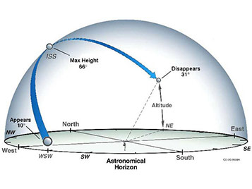
The following ISS sightings are possible from Wednesday Apr 23, 2025 through Thursday May 8, 2025
| Date | Visible | Max Height | Appears | Disappears | Share Event |
|---|---|---|---|---|---|
| Thu Apr 24, 4:31 AM | 4 min | 24° | 20° above S | 10° above E |
|
| Fri Apr 25, 3:45 AM | 2 min | 16° | 16° above SE | 10° above E |
|
| Fri Apr 25, 5:18 AM | 6 min | 66° | 14° above WSW | 10° above ENE |
|
| Sat Apr 26, 4:32 AM | 5 min | 48° | 30° above SSW | 10° above ENE |
|
| Sun Apr 27, 3:46 AM | 3 min | 33° | 33° above SE | 10° above E |
|
| Sun Apr 27, 5:19 AM | 7 min | 79° | 10° above W | 10° above ENE |
|
| Mon Apr 28, 2:59 AM | 1 min | 16° | 16° above ESE | 10° above E |
|
| Mon Apr 28, 4:33 AM | 5 min | 85° | 28° above WSW | 10° above ENE |
|
| Tue Apr 29, 3:46 AM | 3 min | 66° | 65° above SSE | 10° above ENE |
|
| Tue Apr 29, 5:20 AM | 7 min | 64° | 10° above W | 10° above E |
|
| Wed Apr 30, 3:00 AM | 2 min | 26° | 26° above E | 10° above ENE |
|
| Wed Apr 30, 4:33 AM | 6 min | 69° | 18° above W | 10° above ENE |
|
| Thu May 1, 2:14 AM | < 1 min | 12° | 12° above E | 10° above E |
|
| Thu May 1, 3:47 AM | 4 min | 79° | 47° above W | 10° above ENE |
|
| Fri May 2, 3:00 AM | 3 min | 51° | 51° above E | 10° above ENE |
|
| Fri May 2, 4:33 AM | 7 min | 64° | 10° above W | 10° above E |
|
| Sat May 3, 2:14 AM | 1 min | 19° | 19° above E | 10° above ENE |
|
| Sat May 3, 3:47 AM | 5 min | 64° | 28° above WNW | 10° above E |
|
| Sun May 4, 3:00 AM | 3 min | 69° | 69° above NNW | 10° above ENE |
|
| Sun May 4, 4:34 AM | 7 min | 76° | 10° above WNW | 10° above E |
|
| Mon May 5, 2:14 AM | 2 min | 30° | 30° above ENE | 10° above ENE |
|
| Mon May 5, 3:47 AM | 6 min | 67° | 16° above WNW | 10° above E |
|
| Tue May 6, 1:27 AM | < 1 min | 13° | 13° above ENE | 10° above ENE |
|
| Tue May 6, 3:00 AM | 4 min | 63° | 37° above WNW | 10° above E |
|
| Tue May 6, 4:35 AM | 7 min | 70° | 10° above WNW | 10° above ESE |
|
| Wed May 7, 2:14 AM | 3 min | 47° | 47° above NE | 10° above E |
|
| Wed May 7, 3:47 AM | 7 min | 90° | 10° above WNW | 10° above ESE |
|
| Thu May 8, 1:27 AM | 1 min | 17° | 17° above ENE | 10° above ENE |
|
| Thu May 8, 3:00 AM | 5 min | 75° | 28° above WNW | 10° above E |
|
| Thu May 8, 4:35 AM | 6 min | 37° | 10° above W | 10° above SE |
|
{ts '2025-04-24 02:31:00'},Thu Apr 24, 4:31 AM,4 min,24°,20° above S,10° above E|{ts '2025-04-25 01:45:00'},Fri Apr 25, 3:45 AM,2 min,16°,16° above SE,10° above E|{ts '2025-04-25 03:18:00'},Fri Apr 25, 5:18 AM,6 min,66°,14° above WSW,10° above ENE|{ts '2025-04-26 02:32:00'},Sat Apr 26, 4:32 AM,5 min,48°,30° above SSW,10° above ENE|{ts '2025-04-27 01:46:00'},Sun Apr 27, 3:46 AM,3 min,33°,33° above SE,10° above E|{ts '2025-04-27 03:19:00'},Sun Apr 27, 5:19 AM,7 min,79°,10° above W,10° above ENE|{ts '2025-04-28 00:59:00'},Mon Apr 28, 2:59 AM,1 min,16°,16° above ESE,10° above E|{ts '2025-04-28 02:33:00'},Mon Apr 28, 4:33 AM,5 min,85°,28° above WSW,10° above ENE|{ts '2025-04-29 01:46:00'},Tue Apr 29, 3:46 AM,3 min,66°,65° above SSE,10° above ENE|{ts '2025-04-29 03:20:00'},Tue Apr 29, 5:20 AM,7 min,64°,10° above W,10° above E|{ts '2025-04-30 01:00:00'},Wed Apr 30, 3:00 AM,2 min,26°,26° above E,10° above ENE|{ts '2025-04-30 02:33:00'},Wed Apr 30, 4:33 AM,6 min,69°,18° above W,10° above ENE|{ts '2025-05-01 00:14:00'},Thu May 1, 2:14 AM,< 1 min,12°,12° above E,10° above E|{ts '2025-05-01 01:47:00'},Thu May 1, 3:47 AM,4 min,79°,47° above W,10° above ENE|{ts '2025-05-02 01:00:00'},Fri May 2, 3:00 AM,3 min,51°,51° above E,10° above ENE|{ts '2025-05-02 02:33:00'},Fri May 2, 4:33 AM,7 min,64°,10° above W,10° above E|{ts '2025-05-03 00:14:00'},Sat May 3, 2:14 AM,1 min,19°,19° above E,10° above ENE|{ts '2025-05-03 01:47:00'},Sat May 3, 3:47 AM,5 min,64°,28° above WNW,10° above E|{ts '2025-05-04 01:00:00'},Sun May 4, 3:00 AM,3 min,69°,69° above NNW,10° above ENE|{ts '2025-05-04 02:34:00'},Sun May 4, 4:34 AM,7 min,76°,10° above WNW,10° above E|{ts '2025-05-05 00:14:00'},Mon May 5, 2:14 AM,2 min,30°,30° above ENE,10° above ENE|{ts '2025-05-05 01:47:00'},Mon May 5, 3:47 AM,6 min,67°,16° above WNW,10° above E|{ts '2025-05-05 23:27:00'},Tue May 6, 1:27 AM,< 1 min,13°,13° above ENE,10° above ENE|{ts '2025-05-06 01:00:00'},Tue May 6, 3:00 AM,4 min,63°,37° above WNW,10° above E|{ts '2025-05-06 02:35:00'},Tue May 6, 4:35 AM,7 min,70°,10° above WNW,10° above ESE|{ts '2025-05-07 00:14:00'},Wed May 7, 2:14 AM,3 min,47°,47° above NE,10° above E|{ts '2025-05-07 01:47:00'},Wed May 7, 3:47 AM,7 min,90°,10° above WNW,10° above ESE|{ts '2025-05-07 23:27:00'},Thu May 8, 1:27 AM,1 min,17°,17° above ENE,10° above ENE|{ts '2025-05-08 01:00:00'},Thu May 8, 3:00 AM,5 min,75°,28° above WNW,10° above E|{ts '2025-05-08 02:35:00'},Thu May 8, 4:35 AM,6 min,37°,10° above W,10° above SE|